Good morning. This is Dave Zinn with the Gallatin National Forest Avalanche Forecast on Monday, November 28th at 7:00 a.m. This information is sponsored by Alpine Orthopedics & Sports Medicine, Stronghold Fabrication and Knoff Group Real Estate. This forecast does not apply to operating ski areas.
*Note: Bridger Bowl Ski Area is closed and there are no avalanche control or ski patrol services. Backcountry conditions exist. Please don’t ski over hoses and power cords, stay off chairlifts, and give snowcats and snowmobiles plenty of room.
This morning, mountain temperatures are in the single digits to low teens F and yesterday’s strong winds calmed and are currently 10 to 20 mph from the west to northwest. In the last 24 hours, the mountains around Cooke City, West Yellowstone and the Northern Gallatin Range received 7-12” of new snow with 2-3” in the Bridger Range and near Big Sky. Temperatures will warm into the high single digits to mid-teens F with west winds 5-15 mph. The southern portions of our advisory area will receive an additional 2-3” of snow by morning with a trace to 1” in the northern ranges.
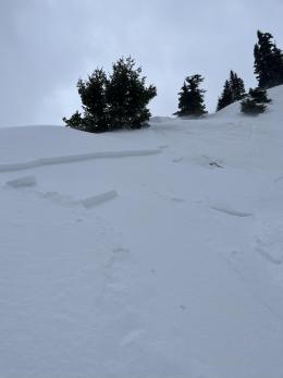
Dangerous avalanche conditions exist in the mountains around West Yellowstone and Cooke City and in the Gallatin and Southern Madison Ranges where, in the last 48 hours, 9-13” of snow fell equal to 0.7-1” of snow water equivalent (SWE). Yesterday, strong winds gusting to 65 mph created unstable drifts at many elevations and aspects. Human-triggered avalanches breaking up to two feet deep are likely on wind-loaded slopes. Larger avalanches breaking deeper into the snowpack are possible.
Smaller slides on steep slopes unaffected by the wind could be large enough to injure or kill riders and skiers, especially where terrain traps like rocks, trees or cliffs enhance the consequences of getting caught in a slide. Watch for signs instability such as recent avalanches, collapsing and cracking that tell us to avoid steep slopes entirely. A snow pit will help test for these new snow instabilities and those lurking deeper in the snowpack.
Today, careful route-finding that avoids steep, wind-loaded slopes, a snowpack assessment focused on identifying instabilities in new and wind-drifted snow along with conservative decision-making are essential. The danger is rated CONSIDERABLE.
In the last 48 hours, the Bridger and Northern Madison Ranges received 7-9” of new snow, equal to 0.5-0.8” of SWE. Strong winds yesterday and the new snow create a heightened avalanche danger, especially on slopes loaded with slabs of wind-drifted snow.
Yesterday, two groups triggered avalanches on wind-loaded slopes within the boundaries of Bridger Bowl (details and photos incident 1, incident 2). These two incidents make four unintentionally triggered avalanches within the boundaries of the closed ski area in the last five days, with one skier carried nearly 150’ (details and photos). During avalanche mitigation work, the Big Sky Ski Patrol triggered numerous avalanches on freshly wind-loaded slopes that broke 12-18” deep. Similar avalanches are possible today.
The Big Sky Ski Patrol triggered one larger slide that failed on deeper weak layers that exist regionally on high-elevation north-facing slopes (details and photos, Hyalite Peak avalanche, natural avalanche on deeper weak layers at Big Sky).
Today, evaluate your terrain choices carefully and assess the snowpack by looking for instabilities in the new and wind-drifted snow. Human-triggered avalanches are possible, and the avalanche danger is MODERATE.
If you get out, please share avalanche, snowpack or weather observations via our website, email (mtavalanche@gmail.com), phone (406-587-6984), or Instagram (#gnfacobs).
Dangerous avalanche conditions exist in the mountains near Island Park where 13” of new snow fell in the last 48 hours, and strong winds blew yesterday. Human-triggered avalanches breaking up to two feet deep are likely on wind-loaded slopes. Larger avalanches breaking deeper into the snowpack are possible. Careful route-finding that avoids steep, wind-loaded slopes, a snowpack assessment focused on identifying instability in new and wind-drifted snow and conservative decision-making are essential.
Upcoming Avalanche Education and Events
Our education calendar is full of awareness lectures and field courses. Check it out: Events and Education Calendar.
Tuesday, November 29, 6 p.m. Sidecountry Avalanche Awareness for Families (and Friends) at Story Mill Park. Free.
Tuesday, December 6, 9 a.m. - 3:00 p.m. West Yellowstone Avalanche Fundamentals w/ Snowmobile Field Session. Pre-register HERE.
We are offering an Avalanche Fundamentals with Field Session course for skiers in December and January, and snowmobilers in early January. Sign up early before they fill up.
Tuesday, December 13, 6 p.m. Avalanche Awareness + Beacons at Story Mill Park. Free.
The Friends of the Avalanche Center are hosting the Powder Blast Fundraiser. Your donations support free and low-cost avalanche education, beacon checkers at trailheads, beacon parks, weather stations, and GNFAC programs! The Friends of GNFAC launched an online GoFundMe campaign. Please consider a donation, and we look forward to having an in-person event again in the future.


