Good morning. This is Doug Chabot with the Gallatin National Forest Avalanche Forecast on Wednesday, March 8th at 6:45 a.m. This information is sponsored by Cooke City Super 8/Bearclaw Bob’s and Spark R&D. This forecast does not apply to operating ski areas.
There’s no new snow to report this morning. Southwest wind is blowing 5-15 mph with gusts of 20 mph, except up Hyalite where it is averaging 25 mph and gusting to 35 mph. Temperatures are in the low single digits F and will rise to 20F under mostly sunny skies this morning. Snowfall will start by later afternoon and drop 1-2” by tomorrow morning with winds of 10-20 mph from the west.
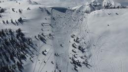
Around Cooke City, the Lionhead area, and also in the northern Gallatin Range, we have weak layers buried 3-5 feet deep that are avalanching. On Sunday, a large avalanche broke on Miller Mountain outside Cooke City with just 3” of new snow…yikes! Yesterday, a 3-foot deep avalanche was triggered by a snowmobiler in Lionhead. And last night winds in Hyalite ramped up and are loading slopes, which is on the heels of a 3-5 foot deep skier triggered avalanche on Hyalite Peak that partially buried him on Saturday. As far as the snowpack is concerned, wind-loading is the equivalent of a snowstorm.
Recent avalanches tell us slopes are unstable. Stability tests can be unreliable when our layer of concern is deep. Although the sun is out and fresh powder abounds, we recommend a cautious approach to route-finding and decision-making because dangerous avalanche conditions exist. We do not advise getting onto steep slopes in these ranges today.
In Hyalite, Dave found a new weak layer of sugary facets buried a foot under the surface. Today’s wind-loads could create avalanches on it. We’ll be looking for this layer in other ranges.
Check out Dave’s excellent video from Hyalite yesterday, Ian’s drone shots from Lionhead, and my avalanche investigation from Saturday in Cooke City. These 3 videos paint a vivid picture of what we are worried about.
The avalanche danger is rated CONSIDERABLE.
In the Bridger Range, the entire Madison Range and southern Gallatins, we have buried weak layers, but at the moment they are not being loaded. However, instabilities seen on Sunday and Monday point to the need to dig and test slopes we want to play on. On Saturday, night riders triggered a 2-3 foot deep slide on Buck Ridge (photo and details). The next day Alex went looking for it and ended up watching cracks shoot away from his sled in the windblown snow (video). In the Bridger Range on Sunday, skiers triggered small wind slabs (observation and photos), and on Monday, skiers found small avalanches in the new snow on the Ramp (observation and photos). Since the possibility of triggering a slide remains, the avalanche danger is rated MODERATE.
Please share avalanche, snowpack or weather observations via our website, email (mtavalanche@gmail.com), phone (406-587-6984), or Instagram (#gnfacobs).
Around Cooke City, the Lionhead area, and also in the northern Gallatin Range, we have weak layers buried 3-5 feet deep that are avalanching. Recent avalanches tell us slopes are unstable. Although the sun is out and fresh powder abounds, we recommend a cautious approach to route-finding and decision-making because dangerous avalanche conditions exist. For reference, we would not get onto steep slopes in these ranges today.
Upcoming Avalanche Education and Events
Our education calendar is full of awareness lectures and field courses. Check it out: Events and Education Calendar.
March 9, 6 p.m.-7 p.m., 1-Hour Awareness - Spring conditions. FREE at REI Bozeman.
March 10 & 11, SheJumps - Women’s Companion Rescue Clinic. Online classroom session Friday evening followed by a field session from 10 a.m.-2 p.m. Saturday. More information and registration HERE.
Every Saturday, 10 a.m. - 2:00 p.m. Avalanche Rescue Training, drop in for any amount of time. Round Lake Warming Hut, Cooke City. Free.
Loss in the Outdoors is a support group for those affected by grief and loss related to outdoor pursuits. Check out the link for more information.
A list of all avalanche activity from our forecast area can be viewed HERE.


