Good morning. This is Dave Zinn with the Gallatin National Forest Avalanche Forecast on Monday, March 13th at 7:00 a.m. This information is sponsored by Alpine Orthopedics & Sports Medicine, Werner Wealth Management (Advisors with DA Davidson) and Advanced Innovation. This forecast does not apply to operating ski areas.
This morning, temperatures are in the teens to 20s F with 10-15 mph winds from the south to the west. The mountains south of Big Sky through West Yellowstone received 1” of new snow, and none elsewhere. Today, temperatures will be in the upper 20s to 30s F with 15-25 mph winds from the southwest. The mountains near West Yellowstone will receive 4-8” of new snow with 2-4” in Cooke City and 2” near Big Sky.
Dangerous avalanche conditions exist in the mountains around West Yellowstone and Cooke City. New snow and strong winds on Thursday and Friday ended a two to three-week period of near-constant snowfall. Human-triggered avalanches breaking within new and wind-drifted snow are likely, and much larger avalanches breaking 4-6 feet deep on buried weak layers are possible. Snow increasing throughout the day will exacerbate these problems in West Yellowstone.
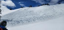
Yesterday, near Cooke City, a group in the flats near Scotch Bonnet reported hearing breaking trees and saw a powder cloud blast out from the bottom of a slope before jumping into action to confirm no one was caught (observation and photo). Alex made a great video describing some of these avalanches, including one on Fisher Mountain that broke 6 feet deep. The snow rangers reported an avalanche that broke an estimated 2000 feet wide near Abundance Lake (photos and details). A group of riders in the Lionhead area near West Yellowstone sent photos of seven avalanches ranging from relatively small to over 1000 feet wide (photos and details). Details about more than a dozen natural and human triggered avalanches this weekend are available on the avalanche activity list.
Certainty relative to avalanches is achievable by avoiding slopes steeper than 30 degrees and their runout zones. Otherwise, select non-wind-loaded slopes, perform a thorough snowpack assessment and choose smaller terrain with fewer terrain traps. The avalanche danger is CONSIDERABLE.
Heightened avalanche danger exists in the Bridger, Madison and Gallatin Ranges, where reports of human-triggered avalanches would not be surprising. Avalanches could break one to two feet deep within the recently wind-drifted snow or on deeply buried weak layers 3-5+ feet deep. The former is more likely, and the latter is more dangerous.
Deep slab avalanches are high-consequence events, and decision-making around them is complex as their occurrence is less likely, signs of instability are limited, and snowpack tests may not provide clear information. This weekend skiers near Electric Peak in the Southern Gallatin Range saw recent large (and small) avalanches (photos and observation) and riders in Tepee Basin reported two slides (photos and observation). These observations are clear evidence that deep slab avalanches like the one I investigated on Hyalite Peak last week are still a dangerous possibility.
Recent drifts of wind-loaded snow may also avalanche. This weekend a group near Big Sky intentionally triggered an avalanche on a wind-loaded slope (photo and details). A natural avalanche failed in Frazier Basin on Friday (photo and details). Similar avalanches are possible today.
Select non-wind-loaded slopes without terrain traps, perform a thorough snowpack assessment and follow safe travel protocols if you enter avalanche terrain.
The danger is rated MODERATE.
Please share avalanche, snowpack or weather observations via our website, email (mtavalanche@gmail.com), phone (406-587-6984), or Instagram (#gnfacobs).
Human-triggered avalanches are likely. These could be relatively small within the recent drifts of wind-loaded snow to very large and nearly unsurvivable, with slides breaking on deeply buried weak layers. Certainty relative to avalanches is achievable by avoiding slopes steeper than 30 degrees and their runout zones. If you enter avalanche terrain, select non-wind-loaded slopes, perform a thorough snowpack assessment and choose smaller terrain with fewer terrain traps. Snow increasing throughout the day will only exacerbate these problems.
See my video from Friday for more information.
Upcoming Avalanche Education and Events
Our education calendar is full of awareness lectures and field courses. Check it out: Events and Education Calendar.
Saturday, 10 a.m. - 2:00 p.m. Avalanche Rescue Training, drop in for any amount of time. Round Lake Warming Hut, Cooke City. Free.
Loss in the Outdoors is a support group for those affected by grief and loss related to outdoor pursuits. Check out the link for more information.
A list of all avalanche activity from our forecast area is available HERE.


