This is Mark Staples with the avalanche forecast on Sunday, April 13th, at 7:00 a.m. sponsored by Bridger Bowl. This forecast does not apply to operating ski areas.
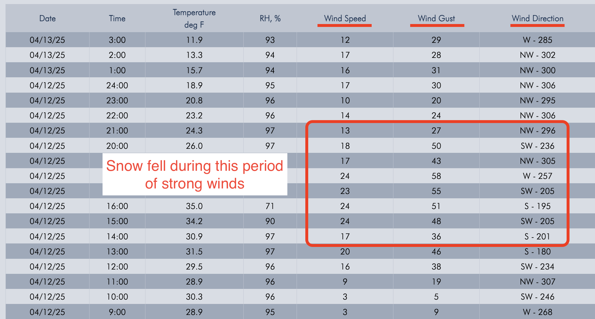
Classic spring weather yesterday afternoon delivered snow in the mountains and rain in the valleys accompanied by lightning and thunder.
- 10” snow (1.1” water) - Cooke City Area
- 6” snow (0.8” water) - northern Gallatin Range
- 2-3” snow (0.2-0.3” water) - Bridger Range and Big Sky area
Temperatures plummeted overnight and range from around 20° F in the Bridgers to low-mid teens F most other places to single digits F at the highest elevations. Strong ridgetop winds during snowfall yesterday blew 20 mph gusting 40-50 changing directions quickly from S to W to NW. Winds have eased this morning.
Today cold air and lingering clouds will remain over the area with a few snowflakes falling in the Bridgers. The sun should start peeking out this afternoon bringing high temps into the mid 30s F in the Bridgers and low to mid 20s F near Big Sky and Cooke City. There will be clear skies and plenty of sunshine near West Yellowstone and Island Park with high temps approaching 30° F. Winds from the WNW will blow in the low teens but could remain a bit gusty in the Bridgers.
Looking ahead - A ridge of high pressure brings warm, dry weather Monday & Tuesday. Another trough descends from Canada bringing more snow and cold air on Thursday. The fight between winter and summer continues.

Wild weather yesterday likely threw down some graupel and other variations in the 10” of dense, new snow along with a period of strong winds. There are two avalanche problems to consider:
Storm slab avalanches - I’m unsure how well the new snow is bonded to itself and the old snow surface, but it should be dense enough to be a cohesive slab. Assess the stability of the new snow before getting into steep terrain - get onto small steep test slopes, step and ride above your partners tracks, and perform quick ECT’s.
Wind slab avalanches - Strong winds during the storm yesterday drifted the new snow and formed wind slabs that could be two feet thick. Look for places with fresh wind loading and ski or ride around those locations where there’s a good chance you’ll trigger a slide.
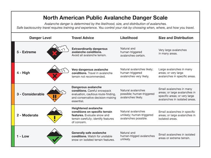
Today near Cooke City the avalanche danger is CONSIDERABLE in any wind-loaded terrain with drifting from yesterday’s winds. Slopes untouched by yesterday’s winds have a MODERATE danger.

Cold temperatures have helped refreeze the snowpack ending wet snow problems. With minimal new snow there are minimal dry snow avalanche problems, but still watch out for shallow wind slabs that could sweep you off your feet.
Today the avalanche danger is LOW. For the few hardy folks venturing into out of the way places, watch out for isolated locations that may have received much higher snowfall amounts. Those places will have the danger and avalanche problems more similar to the Cooke City area.
If you encounter an error with our observation submission platform, please email your observations to mtavalanche@gmail.com
Hyalite Road Closure
The Hyalite Canyon Road is closed to ALL MOTORIZED VEHICLES until May 16. This is a regular annual road closure to reduce road damage during the spring thaw. Bicycle and foot traffic are allowed. Contact the Bozeman FS Ranger District for more info.
Our last daily avalanche forecast will be Sunday, April 20th. We will issue updates on Mondays and Fridays through the end of April.